
Interpolation and Photogrammetric Elevation Derivation in South African Digital Elevation Models
A technical comparison of SUDEM5 and DEMSA2 within the GeoSmart Space elevation-data framework
Prepared as an academic overview, August 2026
Abstract
Digital elevation models (DEMs) can be generated using a range of fundamentally different data sources and modelling approaches. This article examines two approaches represented by GeoSmart Space elevation products in South Africa: interpolation from discrete topographic observations and photogrammetric extraction from stereo aerial imagery. SUDEM5 is primarily an interpolated terrain model derived from discrete elevation constraints, including contours and spot heights, with the Level 1 product generated using the ANUDEM algorithm. DEMSA2, in contrast, is a photogrammetrically derived elevation model generated from overlapping stereo aerial imagery and available as both digital surface model (DSM) and digital terrain model (DTM) products at 2 m resolution. These approaches differ fundamentally in how elevation information is obtained and represented. Interpolation estimates a continuous terrain surface between known elevation observations, whereas photogrammetry derives three-dimensional elevation information from image geometry and subsequent photogrammetric processing. Extrapolation represents a separate mathematical and statistical concept involving the estimation of values beyond the range or spatial support of observed data and should therefore not be used to characterise DEMSA2. The distinction between these methodologies has important implications for spatial detail, terrain representation, observation density, generalisation and the suitability of the resulting elevation models for engineering, hydrological, environmental and other geospatial applications.
1. Introduction
Elevation modelling converts observations of the Earth’s vertical dimension into a spatially continuous representation. The quality and behaviour of the resulting raster depend not only on cell size, but also on the source observations, their spatial density, the physical measurement process, and the algorithms used to construct the surface. GeoSmart Space distributes SUDEM5, a 5 m South African elevation model, and DEMSA2, a 2 m elevation product extracted from stereo aerial imagery. GeoSmart also uses these datasets in downstream products, including FUSEDEM. [1–4]
2. Interpolation and Extrapolation
Interpolation is the estimation of an unknown value within the spatial or numerical range constrained by known observations. In elevation modelling, a set of contours and spot heights can be treated as discrete constraints on an otherwise continuous terrain surface. An interpolation algorithm estimates the elevation of unsampled locations between these constraints.
Extrapolation is different. It estimates values outside the domain supported by the observations. Because the model is no longer bounded by observations on both sides of the estimate, extrapolation generally carries greater uncertainty and is more sensitive to assumptions about the behaviour of the underlying phenomenon.
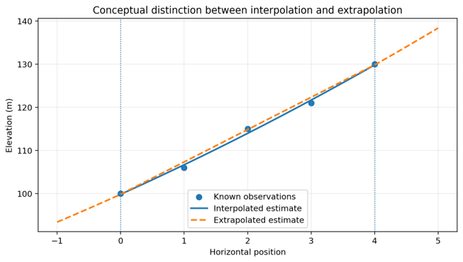
Figure 1. Conceptual distinction between interpolation and extrapolation. Interpolation estimates within the observed domain; extrapolation extends the model beyond it.
3. SUDEM5: An Interpolated Elevation Surface
The SUDEM methodology gives preference to large-scale 1:10 000 contours and spot heights, using 1:50 000 data where larger-scale data are unavailable. The Level 1 product is produced by interpolating contours and elevation points, with ANUDEM identified as the interpolation algorithm. Subsequent SUDEM levels incorporate additional information, including SRTM and imagery-derived products, depending on the level. [5]
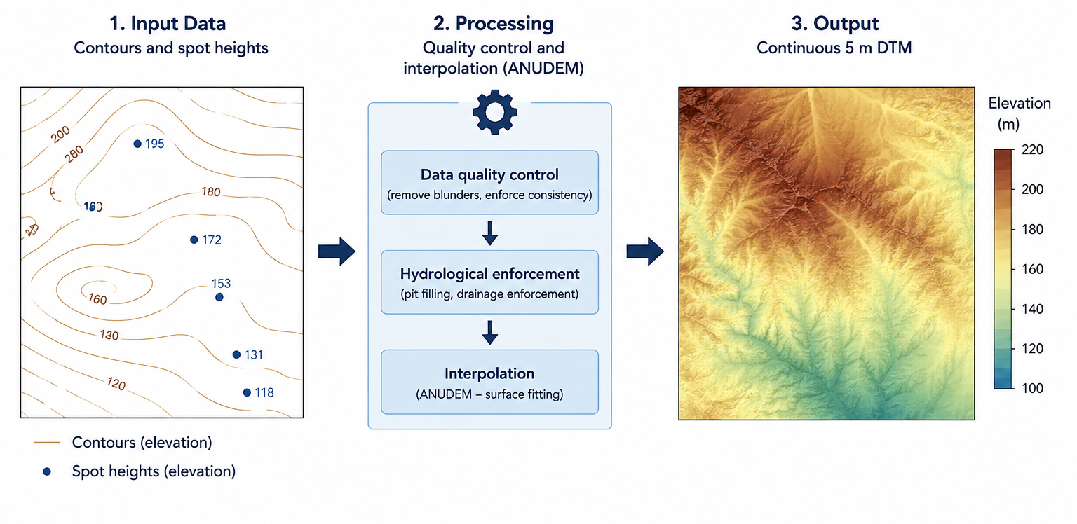
Figure 2. Simplified representation of the SUDEM Level 1 concept: discrete contour and spot-height constraints are quality-controlled and interpolated into a continuous 5 m terrain model.
An important consequence is that SUDEM is influenced by the density and quality of its source observations. The published SUDEM methodology notes that contours are not ideal interpolation inputs because contour density varies with terrain and vertical interval. In relatively flat areas, widely spaced contours can provide fewer constraints and therefore require greater interpolation between observations. The same documentation also identifies possible interpolation artefacts such as banding, tiger-strip and wave effects. [5]
4. DEMSA2: Photogrammetric Elevation Derivation
DEMSA2 represents a different measurement paradigm. GeoSmart describes DEMSA2 as a 2 m elevation model extracted from stereo aerial imagery and provides it in multiple processing levels. L1 is the raw DSM, L2 is a quality-controlled DSM, and L3 is a DTM in which surface features are removed. GeoSmart reports approximately 50 cm vertical accuracy and approximately 1 m horizontal accuracy for the product. [2]
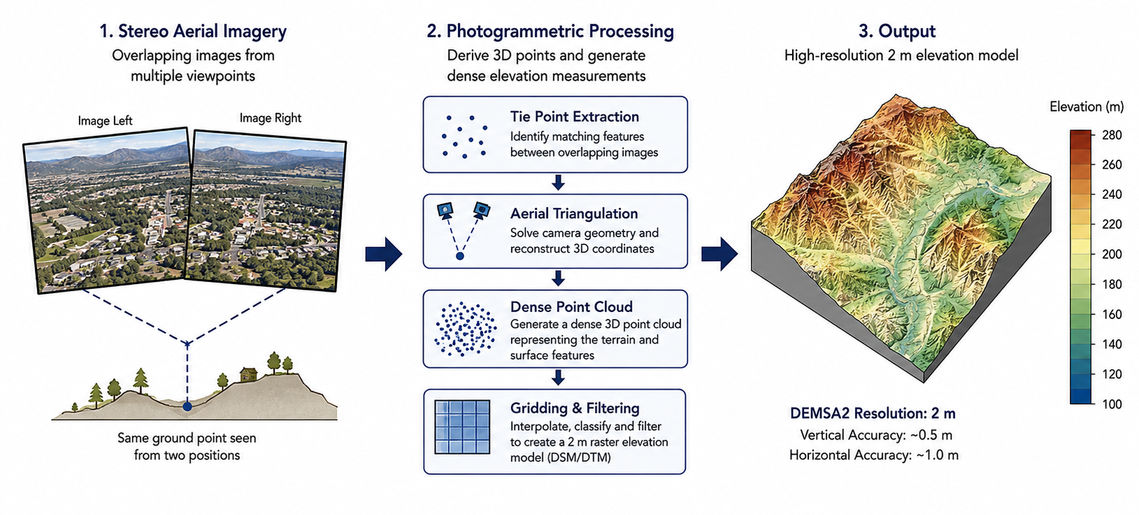
Figure 3. Conceptual photogrammetric workflow for DEMSA2: overlapping imagery supports image matching and three-dimensional point generation, followed by quality control and terrain/surface modelling.
Stereo photogrammetry does not mean that every raster cell is a direct physical measurement. Image matching, point-cloud generation, filtering, gridding, interpolation between valid points, and resampling can all occur within a production chain. Nevertheless, the key distinction is that the primary elevation information is derived from image geometry rather than being reconstructed principally from pre-existing contour lines.
5. Distinguishing Interpolation, Photogrammetry and Extrapolation
The distinction between SUDEM and DEMSA2 is more appropriately understood in terms of their underlying data-generation methodologies. SUDEM is fundamentally an interpolated elevation model, in which discrete elevation observations, including contours and spot heights, are used to estimate a continuous representation of the terrain surface between known observations. DEMSA2, by contrast, is a photogrammetrically derived elevation model, in which three-dimensional elevation information is extracted from overlapping stereo aerial imagery. While interpolation and other spatial processing techniques may be applied during the generation and rasterisation of a photogrammetric elevation dataset, this does not constitute extrapolation.
Extrapolation is a distinct mathematical and statistical concept referring to the estimation or prediction of values beyond the observed range or spatial support of the input data, and is more commonly associated with theoretical modelling, forecasting and predictive analysis.
A more rigorous description is that SUDEM represents an interpolated terrain surface derived from discrete elevation constraints, whereas DEMSA2 represents a photogrammetrically derived elevation surface generated from stereo aerial imagery. This distinction focuses on the actual source and generation of the elevation information and avoids conflating photogrammetric measurement or raster processing with the separate mathematical concept of extrapolation.
6. Observation Density and Terrain Generalisation
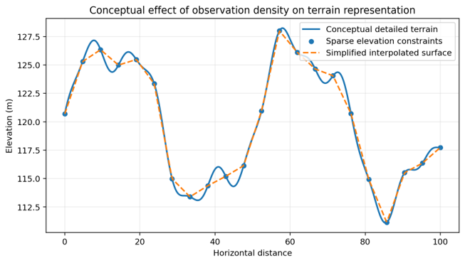
Figure 4. Conceptual illustration of how sparse elevation constraints can yield a more generalised surface than a dense observation set.
The distinction becomes particularly important in terrain with short-wavelength features. A contour-derived surface is constrained by the positions and elevations of the available contours and spot heights. Features that are smaller than the information content of those observations may not be represented explicitly. A photogrammetric workflow can generate a much denser set of spatially distributed elevation observations, allowing finer terrain and surface structure to be represented, subject to image quality, overlap, matching performance, occlusion, and subsequent filtering.
7. DSM, DTM and the DEMSA2 Product Levels
A second distinction is between the type of elevation surface and the method used to generate it. GeoSmart specifies DEMSA2 L1 and L2 as digital surface models (DSM), meaning that elevations include the ground and objects such as vegetation and buildings. DEMSA2 L3 is a digital terrain model (DTM) produced by removing surface features from the L2 DSM. [2,3]
This distinction is independent of interpolation versus photogrammetry. A DSM can be interpolated from observations, and a DTM can contain interpolation steps. ‘DSM/DTM’ describes what the surface represents; ‘interpolated/photogrammetric’ describes how the elevation information is obtained and constructed.
8. Implications for GeoSmart Applications
The different data-generation approaches lead to different strengths. SUDEM5 provides a nationally consistent 5 m elevation surface and is useful for broad-scale terrain, hydrological and environmental applications. DEMSA2 provides substantially finer spatial detail and is suited to applications requiring high-resolution surface or terrain information, including construction, renewable-energy planning, telecommunications, agriculture, disaster-risk planning and urban development. [1,2]
GeoSmart’s FUSEDEM further demonstrates that these approaches need not be treated as mutually exclusive. GeoSmart describes FUSEDEM as a 5 m product that combines 2 m DEMSA2 L3 with SUDEM, with the stated objective of providing broader coverage and terrain information alongside higher-resolution DEMSA2 data. [4]
9. Recommended Technical Terminology
For academic papers, product documentation and client-facing technical material, the following terminology is recommended:
- SUDEM5: ‘a contour- and spot-height-derived, interpolated 5 m elevation model.’
- DEMSA2: ‘a photogrammetrically derived 2 m elevation model extracted from stereo aerial imagery.’
- DEMSA2 L1/L2: ‘digital surface models (DSM) containing ground and surface features.’
- DEMSA2 L3: ‘a digital terrain model (DTM) representing the filtered bare-earth terrain.’
- Extrapolation: reserve the term for predictions outside the spatial or numerical domain supported by observations.
10. Conclusion
Interpolation and extrapolation describe different forms of estimation, while photogrammetry describes a measurement and reconstruction technology. SUDEM5 is appropriately characterised as an interpolated model because its foundational Level 1 surface is generated from contours and spot heights using ANUDEM. DEMSA2 is more accurately described as a photogrammetrically derived elevation model based on stereo aerial imagery. The practical difference is that SUDEM’s spatial detail is constrained by the distribution and quality of pre-existing elevation observations, whereas DEMSA2 derives dense three-dimensional information from imagery before subsequent DSM/DTM processing. This distinction provides a more scientifically defensible explanation of why the products differ in resolution, terrain detail and typical use cases.
References
- GeoSmart Space. (2026). SUDEM5 and GeoSmart elevation product information. GeoSmart Space.
- GeoSmart Space. (2026). 2 m Digital Elevation Model of South Africa (DEMSA2). GeoSmart Space.
- GeoSmart Space. (2026). Sample Datasets: SUDEM5, DEMSA2 L1, L2 and L3. GeoSmart Space.
- GeoSmart Space. (2026). FUSEDEM for Civil Designer / FUSEDEM via API. GeoSmart Space.
- van Niekerk, A. (2016). Stellenbosch University Digital Elevation Model (SUDEM): 2016 Edition (v16.xx). Centre for Geographical Analysis, Stellenbosch University. DOI: 10.13140/RG.2.1.3015.5922.
Source links
GeoSmart Space: https://www.geosmart.space/
GeoSmart DEMSA2 product page: https://www.geosmart.space/Products/2-m-digital-elevation-model-of-south-africa-demsa2/
GeoSmart sample datasets: https://www.geosmart.space/sample-datasets/
GeoSmart FUSEDEM: https://www.geosmart.space/fusedem-for-civil-designer/