
Description
Derived from our high-resolution DEMSA2, our viewshed product offers an accurate and detailed line of sight analysis solutions for your planning needs.
Use-Cases
Our viewshed product aims to provide critical planning information for agricultural, mining, energy and urban development applications. Example applications include the following:
- Modelling wireless internet coverage for an internet of things (IoT) system installation.
- Predicting the visibility of planned wind turbines for an environmental impact study.
- Evaluating potential sites for a telecommunications installation.
Placing an Order
When placing an order, please send an email to info@geosmart.space and provide the following:
- A brief description of your use case, such that we have some context when conducting our analysis and provide additional support.
- A set of points for which to conduct the analysis. This can be provided as a geospatial point file or as a table in the following format:
| y coordinate (latitude) | x coordinate (longitude) | Observer height (metres) |
- The target elevation for analysis. This is an offset to be added to the surface model when conducting the analysis. It can be helpful in cases where you are looking for a location to put up a signal mast of a specified height.
- An analysis extent, either as a geospatial polygon or as a radius from the centroid of the provided points.
- Your preferred product format(s).
Product Specification
Your GeoSmart viewshed product delivery can consist of any or all of the following:
- A georeferenced visibility raster for use in GIS software or Google Earth.
- A georeferenced line dataset (shapefile), indicating the visibility network for the provided points.
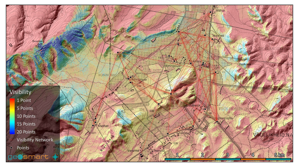
- A pdf map consisting of the visibility raster, visibility network and DEMSA2 hillshade of your order area (example below).
Pricing
As a base offering, we will process up to 10 points for a single area of up to 100 km² for R1750,00. We are happy to add more points, increase the site or add additional locations for an added cost. Please see the following table for a guideline for calculating order costs.
| Product | Details | Price |
|---|---|---|
| Base order | Up to 10 points, for a single area of interest of up to 100 km². | R1 750.00 |
| Additional points | Additional points, or an updated set, can be provided at R150 per point. | R150 per point |
| Larger area | An additional R20 per km² for every km² over 100 km². | R20 per km² |
| Additional area of interest | Additional areas are processed at R500 per area. | R500 per AOI, R20 per km² |
| Orthorectified RGB aerial mosaic | Provided as a georeferenced raster. | R6 per km² |
Please note that this table is but a rough guideline on pricing. Quotations will be done on a case-by-case basis, and may include discounts. Please get in touch to find out more.
*Note that 15% VAT will be added to the cost for South Africa based clients.
Estimate Cost and Request a Quote
Complete the form and we’ll be in touch as soon as possible.
Step 1: Select Product
Step 2: Specify Area of Interest (AOI)
Step 3: Inspect Price Estimation
Product Cart
| AOI Name | Product | AOI Area | Price per km² | Processing Fee | Total Price (Excl. VAT) | Total Price (Incl. VAT) | Actions |
|---|
Summary
| Subtotal (Excl. VAT): | R 0.00 |
| VAT (15%): | R 0.00 |
| Grand Total (Incl. VAT): | R 0.00 |
For large orders (>5 000 km2), please contact us directly as such orders are often heavily discounted.